Terlaris FURUNO GP-39 GPS Navigator (Chart-Plotter) ORIGINAL


Detail Produk
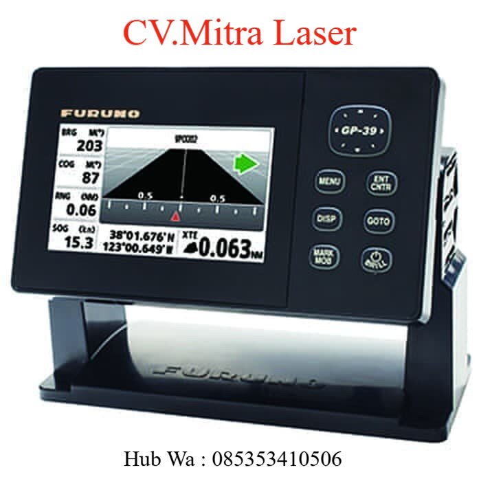
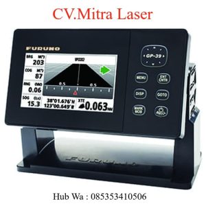
FURUNO GP-39 GPS Navigator (Chart-Plotter)
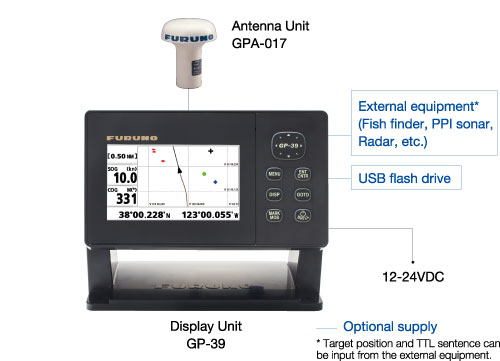
FURUNO GP-39 GPS Navigator (Chart-Plotter) ORIGINAL provides accurate and reliable position fixing, thanks to a 12-channel GPS receiver combined with integrated SBAS (WAAS/EGNOS/MSAS) technology.
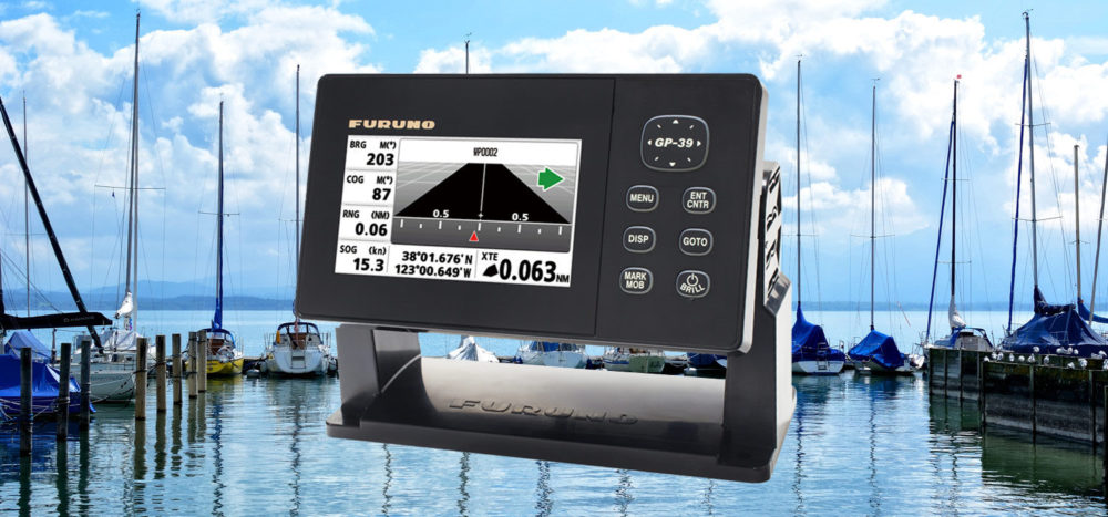
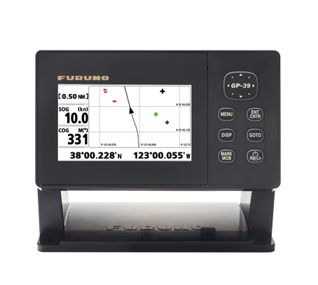
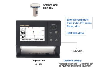
The GP-39 has various display modes (Plotter, Highway, Steering, NAV data, Satellite monitor and 2 user customizable modes) on the 4.2″ color LCD. Up to 3,000 points of ship track, 10,000 waypoints and 100 routes (each with up to 30 waypoints) can be stored. The waypoint and route data can be exported/imported via a USB flash drive or signal converter.
The GP-39 can be networked with a fish finder, sonar, radar or other navigation equipment for feeding highly accurate navigation data.
Features
- Newly Designed GPS Core Delivers Enhanced Position Fixing Accuracy
- 4.2″ High-Resolution Color LCD
- Storage for 3,000 Track Points, 10,000 Waypoints and 100 Routes
- SBAS Capable for Better Positioning Calculations*
* SBAS is a general term for a GPS navigation system with differential correction by means of geostationary satellites. In the US, its is called WAAS (Wide Area Augmentation System), where as in Europe and Japan, it is called EGNOS (European Geostationary Navigation Overlay System) and MSAS (MSAT Satellite-based Augmentation System), respectively. - Share and Display Position Information on Networked Equipment such as a Fish Finder, Sonar, Radar, etc.
- 7 Display Modes Available, Including 2 User-Customizable Modes
- Waypoint and Route Data can be Exported/Imported via a USB Flash Drive or Signal Converter
- Multi-Language Ready: English, French, Spanish, Chinese, Vietnamese, Malay, Indonesian and Thai
- Easy to Mount On/Off the Bracket
Specifications
GENERAL |
|
| Product Name | GNSS NAVIGATOR |
DISPLAY |
|
| Screen Size | 4.2” color LCD |
| Effective Display Area | 92 (W) x 52 (H) mm |
| Pixel Number | 480 (V) x 272 (H) pixel |
| Display Mode | Plotter, Highway, Steering, NAV Data, Satellite Monitor, User Display (Display, Speedometer, COG) |
| Memory Capacity | 3,000 ship’s track points |
| 10,000 waypoints with comments | |
| 100 routes with 30 waypoints/rpute | |
| Alarm | Arrival and Anchor watch, Cross track error, Speed, WAAS (SBAS), Time, Trip |
GPS/SBAS (WAAS/EGNOS/MSAS) |
|
| Receiver Type | GPS: 12 channels parallel, 12 satellites tracking, C/A code, all-in-view SBAS: 2 channels |
| Receive Frequency | L1 (1575.42MHz ±1.023MHz) |
| Time to First Fix | Cold start: 90 second approx. |
| Tracking Velocity | 1,000 kn |
ACCURACY |
GPS: 10 m (95% of the time, HDOP ≤4) WAAS: 3 m (95% of the time, HDOP ≤4) MSAS: 7 m (95% of the time, HDOP ≤4) |
INTERFACE |
|
| Ports | NMEA0183: 1 port; USB: 1 port |
| Output | AAM, APB, BOD, BWC, BWR, DTM, GGA, GLL, GSA, GSV, RMB, RMC, VTG, XTE, ZDA |
| Input | RTE, TLL |
POWER SUPPLY |
12 – 24V DC, 0.7 – 0.3A |
ENVIRONMENT |
|
| Temperature | Display Unit: -15°C to +55°C |
| Antenna Unit: -25°C to +70°C | |
| Relative Humidity | 93% or less at +40°C |
| Waterproofing | Display unit: IP55 |
| Antenna unit: IP56 | |
EQUIPMENT LIST |
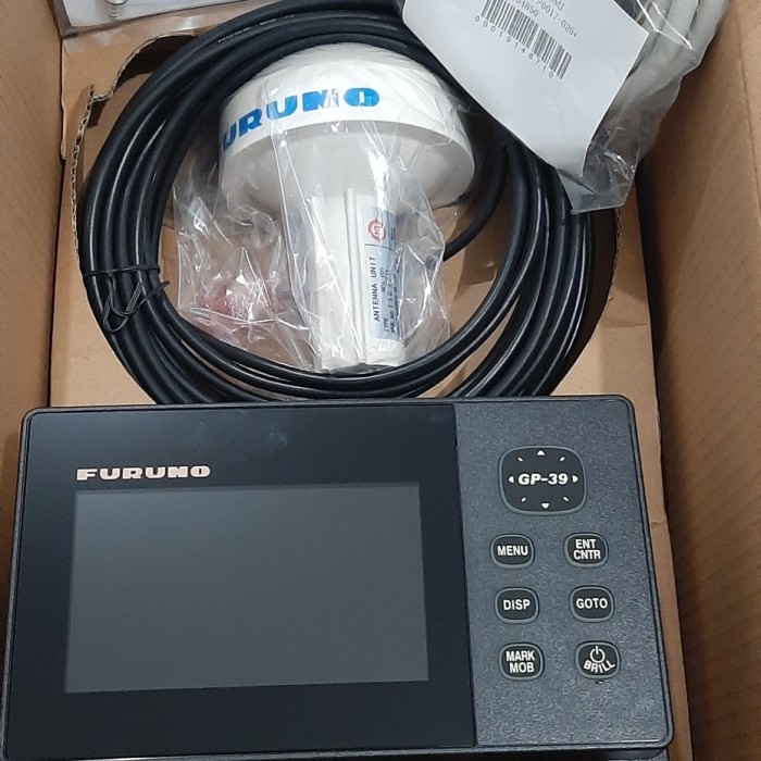
Display Unit GP-39 Antenna Unit GPA-C01 with Cable 10m Plastic Bag Standard Spare Parts and Installation Materials |
| Datasheet | GP-39_EN |
 Terlaris FURUNO GP-39 GPS Navigator (Chart-Plotter) ORIGINAL[/caption]
Mohon Tanyakan Stok Terlebih Dahulu Sebelum Order.
Untuk Pemesanan dan Informasi Harga Terbaik, Hubungi :
Rifki Faisal Bahri
HP : 085353410506 / 089618877628 / 089531793777
Whatsapp : 085353410506
Email : rifkifaisal93@gmail.com / rifky.gps93@gmail.com
Office :
Cv.Mitra Laser
Jl.Inpres 18 Komplek Sabar Ganda No 11 Tangerang selatan 15154
Produk Terkait