CHC M5 GNSS RTK
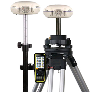
CHC M5 GNSS RTK GPS Geodetic
CHC M5 GNSS RTK adalah salah satu GPS Geodetic yang paling efektif yang dipilih oleh sejumlah besar surveyor untuk kinerja dan keandalannya yang luar biasa.
Key Features :
384 channels multi-constellation receiver
Multiple frequencies for GPS, GLONASS and BDS
Integrated network, UHF modem and Bluetooth
Compact and rugged design
Cost-effective GNSS RTK
Outstanding 384 channels multi-constellation tracking support GPS, GLONASS and BDS for obstructed sky conditions to guarantee RTK accuracy and reliability in field.
Perfect compatibility with Android based field surveying software LandStar 7 provides a epoch-making experience for various and flexible working industries.
M5 innovative design integrates a built-in GNSS core, multi-constellation antenna, Bluetooth communication, RX UHF data link and network modules in one single receiver.
M5 GNSS receiver brings extremely affordable GNSS RTK solution to surveyors without high cost.
Technical Specifications
GNSS Characteristics
- 384 channels with all in view simultaneously tracked satellite signals
-GPS: L1, L2, L5
-GLONASS: L1,L2
-BDS: B1,B2,B3
- Advanced multipath mitigation technology
- Low noise carrier phase measurement
GNSS Accuracies
- Real Time Kinematics (RTK):
-Horizontal: 10 mm + 1 ppm RMS
-Vertical: 15mm + 1 ppm RMS
-Initialization Time: < 10 s
-Initialization Reliability: > 99.9%
- Post-processing Static:
-Horizontal: 8 mm + 1 ppm RMS
-Vertical: 10 mm + 2 ppm RMS
Commucations
- Integrated 3G network modem
- UHF Modem Internal Rx: 450 MHz to 470 MHz
- UHF Modem External Tx DL6: 1 W to 28 W adjustable
- Protocols:
-RTCM2.x, RTCM3.x, CMR
-NMEA 0183 output
-HCN outputs for GNSS raw data (convertible to Rinex static format)
- Bluetooth V2.0
- Serial: 1 x 10-pin LEMO port (external power, USB data download, USB update, RS-232)
- Data Storage
-4 GB internal memory
-GPS device mounts as a USB external hard drive
Physical
- Size (H x D): 84 mm x 179 mm (3.3 in x 7.0 in)
- Weight: 1.4 kg (49.4 oz) with battery
- Environment
-Operating: -40°C to + 65°C (-40°F to + 149°F)
-Storage: -40°C to + 75°C (-40°F to + 167°F)
- Humidity: 100% condensation
- Dust and Water Proof: IP67
- Shock and Vibration: 2 m (6.56 ft) fall onto concrete
Electrical
- Power Consumption: 3.5 W (depending on user settings)
- Li-ion Battery Capacity: 3400 mAh
- Operating Time : Typical 4 h in RTK mode
- External Power: 9 V DC to 18 V DC