CHC i80 GPS Geodetic RTK
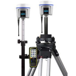
CHC i80 GPS Geodetic RTK GNSS System
CHC i80 GPS Geodetic RTK merupakan alat ataupun perangkat yang digunakan untuk menerima sinyal berupa gelombang sinus yang dipancarkan oleh satelit GPS. Receiver GPS diletakkan pada permukaan bumi guna menerima sinyal tersebut dan mengolahnya menjadi suatu data tertentu.
220 channels with all in view simultaneously tracked satellite signals
GPS: L1C/A, L1C, L2C, L2E, L5
GLONASS: L1C/A,L1P, L2C/A, L2P, L3
Galileo: E1, E5A, E5B
BeiDou: B1, B2
SBAS: L1C/A, L5 (QZSS, WAAS, EGNOS, GAGAN)
GNSS Accuracies, Gps Geodetic CHC i80
SBAS differential positioning accuracy: 0.5 m RMS
Highprecision static
Horizontal: 2.5 mm + 0.5 ppm RMS
Vertical: 3.5 mm + 0.5 ppm RMS
PostProcessed Kinematic (PPK)
Horizontal: 8 mm + 1 ppm RMS
Vertical: 15 mm + 1 ppm RMS
RTK
Horizontal: 8 mm + 1 ppm RMS
Vertical: 15 mm + 1 ppm RMS
Initialization time < 5 s
Initialization reliability > 99.9%
Network RTK
Horizontal: 8 mm + 0.5 ppm RMS
Vertical: 15 mm + 0.5 ppm RMS
Initialization time < 10 s
Initialization reliability > 99.9%
Hardware
Dimensions (H×W): 14 cm × 12.4 cm (5.5 in x 4.9 in)
Weight: 1.02 kg (2.2 lbs) Kg (2.69 lbs) with batteries
Environment
Operating: 40 °C to +75 °C (40°F to 167°F)
Storage: 55 °C to +85°C (67°F to 185°F)
Humidity: 100% condensation
Dust and Waterproof: IP67, protected from temporary immersion to depth of 1 m (unit floats)
Shock and vibration: 2 m (6.56 ft) pole drop onto concrete, MILSTD810G
LCD: 128x64dpi sunlight readable with function/accept buttons
Certifications and Calibrations
FCC Part 15 (Class B Device), FCC Part 22, 24, 90; CE Mark; CTick;Bluetooth EPL, IGS & NGS Antenna Calibration, MILSTD810G.
Communications and Data Recording
Serial: 2 x 7pin LEMO port (external power, USB data download, USB update, RS232)
Cellular: Internally integrated 3.75G modem
HSPA+ 21 Mbps (download), 5.76 Mbps (upload)
WCDMA 850/900/1700/1900/2100
EDGE/GPRS/GSM 850/900/1800/1900
Bluetooth®: Internally integrated multimode system compatible with Android, Windows Mobile and Windows desktop operating systems
WiFi: 802.11 b/g/n, access point mode
UHF Radios : Protected TNC Female
Standard Internal Rx/Tx: 410 470 Mhz;Transmit power: 0.1 W to 2 W;Protocol CHC, Trimble, Pacific Crest; Range: 5 km optimal conditions
CC Certified Internal Rx/Tx: 403 473 Mhz; Transmit power: 0.1 W to 1 W;Protocols Trimble, Satel, Pacific Crest;Range: 5 km optimal conditions
Protocols
CMR, CMR+, sCMRx input and output
RTCM 2.1, 2.2, 2.3, 3.0, 3.1, 3.2 input and output
NMEA 0183 output
HCN and RINEX static formats
NTRIP Client, NTRIP Caster
Data Storage
32 GB highspeed memory
Electrical
Power consumption: <3.2 W
Liion battery capacity: 2 × 3400 mAh, 7.4 V
Operating time:
RTK UHF Base: 6 h
Static: 12 h
External power: 12 to 36 V DC
Kelengkapan :
2x CHC i80
2x Antenna
4x Lithium Battery
Charger Slot Battery
3M Steel Tape
Cabel Charger
Cabel HC1805CNT07
2,2M Survey Pole Carbon
Controller
Alumunium Tripod
Tribrach
Extention Pole 30cm