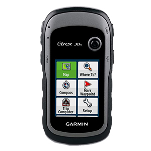
Garmin GPS eTrex 30x
Detail Produk
GPS Garmin eTrex 30x, 3-axis Compass: Better Resolution and Memory
Greater resolution with 240 x 320 display pixels for improved readability
Internal memory expanded to hold more maps
Worldwide basemap with shaded relief
2.2-inch, 65K color, sunlight-readable display
3-axis compass and barometric altimeter
eTrex 30x is our upgraded version of the popular eTrex 30, with enhanced screen resolution for a more readable display and internal memory expanded to hold more maps. It retains the ease-of-use, durability and affordability that eTrex is legendary for and can also be used on ATVs, bicycles, boats, cars or hot air balloons.
Physical & Performance |
|
| Physical dimensions | 2.1″ x 4.0″ x 1.3″ (5.4 x 10.3 x 3.3 cm) |
| Display size, WxH | 1.4″ x 1.7″ (3.5 x 4.4 cm); 2.2″ diag (5.6 cm) |
| Display resolution, WxH | 240 x 320 pixels |
| Display type | 2.2″ transflective, 65K color TFT |
| Weight | 5 oz (141.7 g) with batteries |
| Battery | 2 AA batteries (not included); NiMH or Lithium recommended |
| Battery life | 25 hours |
| Water rating | IPX7 |
| High-sensitivity receiver | |
| Interface | USB |
| Barometric altimeter | |
| Electronic compass | |
| Unit-to-unit transfer (shares data wirelessly with similar units) | |
Maps & Memory |
|
| Basemap | |
| Ability to add maps | |
| Built-in memory | 3.7GB |
| Accepts data cards | microSD™ card (not included) |
| Custom POIs (ability to add additional points of interest) | |
| Waypoints/favorites/locations | 2000 |
| Routes | 200 |
| Track log | 10,000 points, 200 saved tracks |
Outdoor Features |
|
| Automatic routing (turn by turn routing on roads) | Yes (with optional mapping for detailed roads) |
| Geocaching-friendly | Yes (Paperless) |
| Custom maps compatible | |
| Sun and moon information | |
| Tide tables | Yes (with optional Bluechart) |
| Area calculation | |
| Picture viewer | |
Produk Terkait